
Directions to Maleny
Looking for Directions to Maleny
In this article we look at how to get to Maleny whether you are an international visitor, domestic tourist, or a local day tripper.
For those Flying into Queensland
If you are flying internationally, your nearest direct point of entry is Brisbane International Airport. For those flying from within Australia, you can choose to arrive via Brisbane Domestic Airport (BNE), or Sunshine Coast Airport (MCY). Flying via Brisbane gives you greater flexibility in flights, but Sunshine Coast Airport near Maroochydore is closer.
Below we have outlined public transport options, popular routes if you are driving, and transit times for each option.
Directions to Maleny from Brisbane Airports
By car:
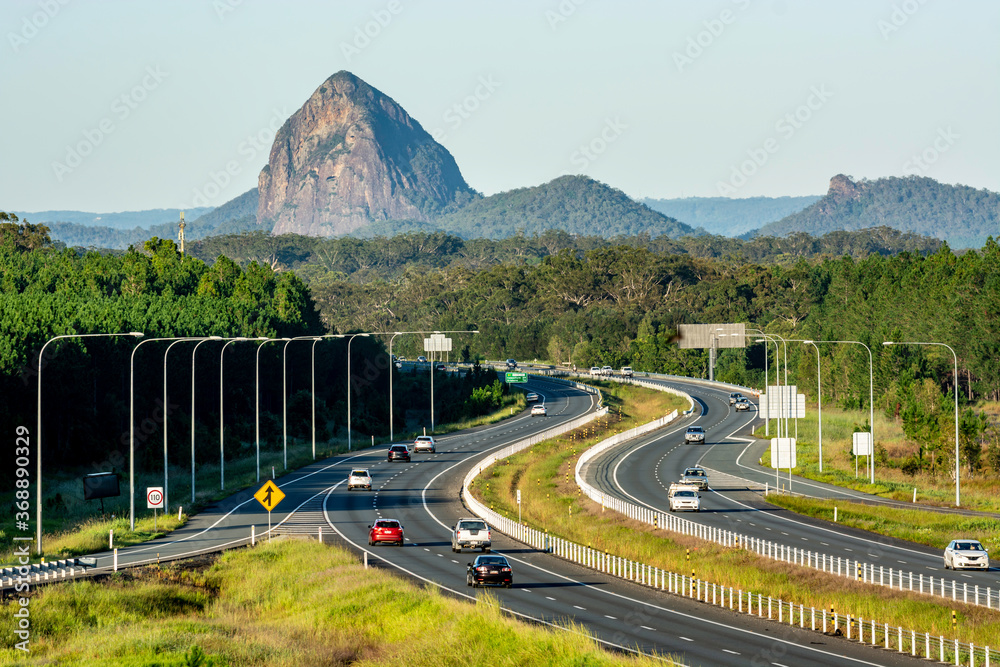
All of the Major Car Hire companies are based at Brisbane Airports, so hiring a car if necessary is easy. The Airports are approximately 95 kilometres from the Maleny township, but it is a pretty straight-forward journey.
Driving time during off-peak periods is around 90 minutes, but between 3pm and 5pm it can easily take an additional 30 minutes due to heavy traffic.
On driving out of the Airport simply look for the Sunshine Coast exit. This will take you to the Bruce Highway (M1) northbound. Once on the highway, take exit 163 onto Steve Irwin Way. After passing Australia Zoo, watch for the exit left into Landsborough and follow the Landsborough-Maleny Road for 17Km to Maleny.
By Public Transport:
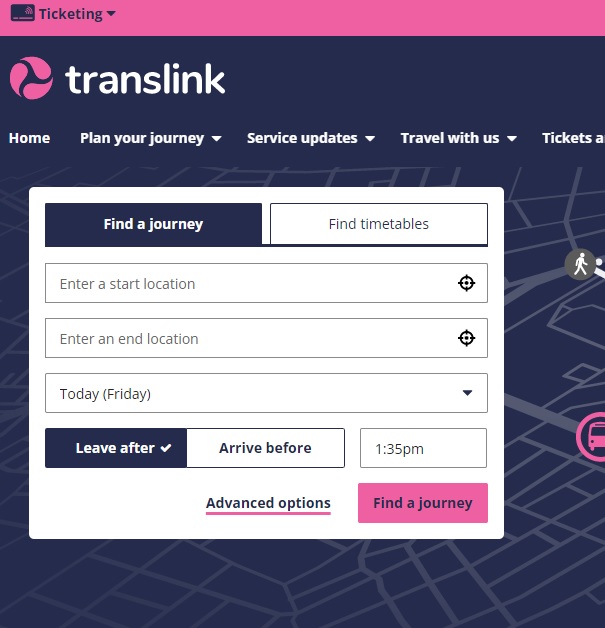
If you are traveling by Public Transport, Translink is a great resource for planning your trips, buying or refunding tickets and much more.
Trains leave either Airport regularly, linking up with services on the Northbound Caboolture and Nambour Lines.
Detrain at Landsborough station and take the connecting buses to Maleny.
Transit time in total is around 3 hours depending on connections.
You can get transit times and connections from Translink
Getting from Sunshine Coast Airport (MCY) to Maleny
By car:
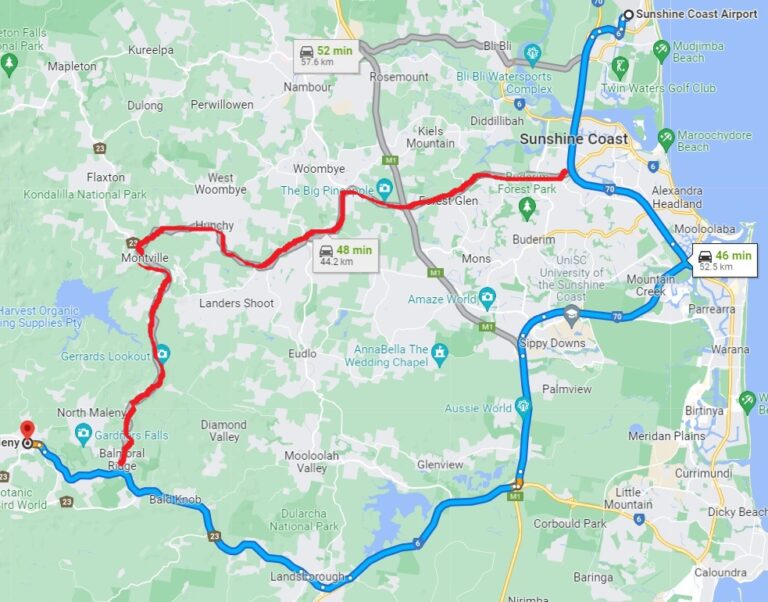
There a two main routes from Sunshine Coast Airport to Maleny. Travel times vary between 45 and 47 minutes depending on your choice.
The most used route is outlined here in Blue .Simply follow Sunshine Motorway (State Route 70), which links up with the Bruce Highway southbound. Take exit 188 and follow the signs to Landsborough. From there it’s an easy drive on the Landsborough-Maleny Rd for 17 kilometres to Maleny.
Alternatively, you can take the more scenic route (in Red) via Palmwoods and Montville. To take this route, again start out on Sunshine Motorway (70) but take a right on Maroochydore Road (state Route 8).
This will take you across the Bruce Hwy, and past the Big Pineapple. Take the turnoff towards Palmwoods, drive through the township watching for the signs toward Monteville. There are two roads taking you up the mountain, I recommend the right turn onto Hunchy Road.
As you enter Montville, turn left onto Maleny-Montville Road (23). This will take you through the picturesque Montville township, and on towards Maleny. Along the way you will see Lake Baroon on your right, and magnificent views back over Caloundra, Maroochydore etc and out to the Pacific Ocean coast. The road ends at a “T” intersection where you take a right for the final 6-7 kilometre drive into Maleny Township.
For other items of interest in the Blackall ranges, visit Queensland and Beyond.
By Public Transport :
Generally, this journey requires 3 connecting buses. You start on Bus 622 from the Airport to the Maroochydore Train station. Change to bus 615 for the trip to Landsborough and then jump on Bus 891 for the last leg to Maleny. The trip takes about 2 hours 30 minutes.
Connections can vary depending on the day and time of travel. For best results always use Translinks Journey planner to see the best options available at the time you plan to travel.
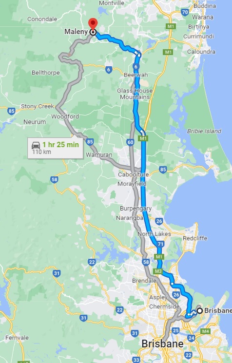
Directions to Maleny from Brisbane
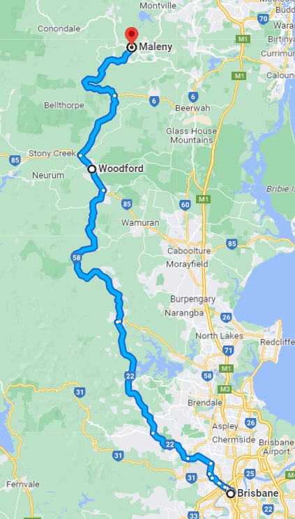
By car there are two routes we would recommend.
The first and most direct option is to take Sandgate Road to the Gateway motorway (northbound), and follow that to the Bruce Highway. Then take exit 163 onto Steve Irwin Way. 4 kilometres after passing Australia Zoo, exit left into Landsborough and follow the Landsborough-Maleny Road for 17Km to Maleny. Basically the same map as used when driving from the Airport (above).
Alternatively, you can take a more scenic drive. Head out to Samford Village, then turn north on route 22 to Dayboro before following route 58 up into the hills at Mt Mee, and on through Woodford. Then climb up to Maleny via Booroobin and Wortha.
In all this trip takes about 2 hours. It is a more scenic drive but these are narrow country roads as compared to the 6 lane Bruce highway. Thus it will be more tiring for the driver but if you have the time, and you are not towing a caravan it might be more interesting.
The Highway between Maleny and Brisbane (southbound) can be extremely congested and slow on Sunday afternoon’s, or after holiday weekends. This is an alternative route that might suit you and save some frustration as well.
Directions to Maleny from other popular locations.
From the Gold Coast
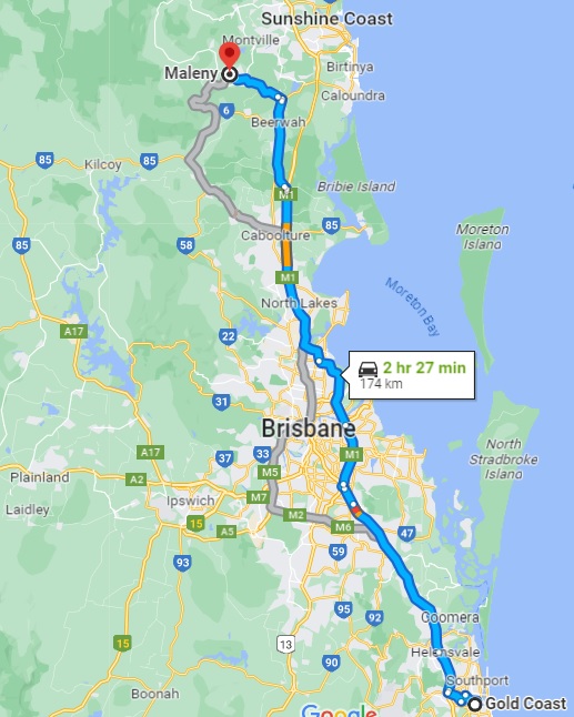
Simple but a bit boring. Just jump on to the Pacific Highway (M1) northbound.
It will Bi-pass Brisbane and take you to the Bruce Highway via the Gateway Motorway.
Once on the Bruce Highway use exit 163 onto Steve Irwin Way.
4 kilometres after Australia Zoo, exit left into Landsborough and follow the Landsborough-Maleny Road for 17Km to Maleny.
In off peak this trip is about 2 hours 40 Minutes
From Ipswich:
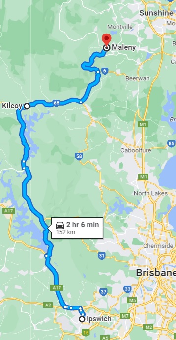
If you are coming from the west of Brisbane I suggest you use the Brisbane Valley Highway (A17)
This will take you past Wivenhoe Dam to Kilcoy.
Then use D’agullar Highway (85) to connect with the Kilcoy-Beerwah Rd (6). Watch for the left turn on to Maleny-Stanley River Road.
This will take you up into Maleny main street arriving on the Western end of Town.
The journey is just over 2 hours with no Tolls, ad avoids all the Brisbane and Bruce Highway traffic.
Alternatively, you can head across either Centenary Highway or the M1, but both take longer and Tolls are required.
Driving to Maleny from the North
If you are approaching from the North, just stay on the Bruce Highway. After you pass Aussie World, look for and take exit 188. Follow the signs to Landsborough. From there its an easy drive on the Landsborough-Maleny Rd for 17 kilometres to Maleny.
Basically, directions to Maleny are pretty straight forward from most areas of Queensland due to its proximity to the Bruce Highway, But, finding alternatives routes during peak hours can add interest and reduce the frustration of heavy traffic.
Getting around Maleny
Once in Maleny everything within the Township is walking distance, but many of the attractions, and much of the accommodation is not. Whilst there are regular bus services to and from the town, the only way to and from most areas is by private car.
The local taxi service is limited to only a few vehicles, so having your own vehicle, or teaming up with a local will make seeing the area much easier.